LET OP: Aankopen verlopen via de App Store, controleer daar altijd de meest actuele prijs, compatibiliteit en andere informatie. Je hebt een actief Apple account nodig om apps te installeren.
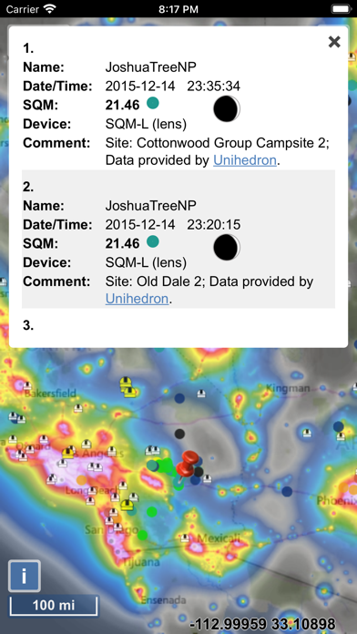
The map displays VIIRS/World Atlas/Clouds/Aurora/IAU observatories and the user SQM measurements.
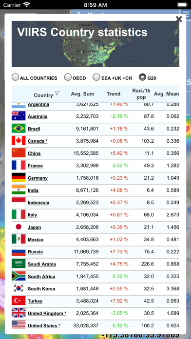
The primary use is to show VIIRS/DMSP data in a friendly manner, but over time it also included some other interesting overlays that concern light pollution like SQM/SQC, World Atlas 2015 zenith brightness, clouds, aurora and IAU observatories. If you have a permanent SQM reader installed you can add it to the map by sending me an e-mail.
Please send comments and requests for new features via email (look under help)
Functionalities:
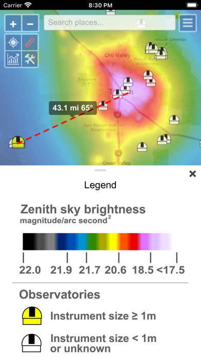
- VIIRS, Sky Brightness, World Atlas 2015, Cloud coverage and Aurora forecast layers
- VIIRS and Sky Brightness layers can be displayed in color blind friendly colors
- Road & Satellite base maps
- Cloud animation for the last 12 hours
- Get detail radiance and SQM values from layers at a click. For Sky brightness/World Atlas 2015, you also get Bortle class estimation.
- SQM, SQM-L, SQC, SQM-LE, SQM readings submitted by users
- International dark sky parks overlay
- Submit your own SQM (L) readings
- Observatories layer
- Save your favorite locations
- Distance measurement tool with azimuth angle report
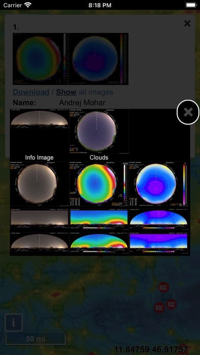
- All-sky view of light pollution with real horizon
- Offline mode (Sky brightness map and a base map are saved to your device, so it will be displayed when you are offline)
--
Light Pollution Map van Jurij Stare is een app voor iPhone, iPad en iPod touch met iOS versie 15.0 of hoger, geschikt bevonden voor gebruikers met leeftijden vanaf 4 jaar.
Informatie voor Light Pollution Mapis het laatst vergeleken op 23 Jun om 10:39.
- Feature filters can be now be saved (settings). Name field also supports wildcard searching for example '*town OR john*' will display 'Smalltown' and 'Johnstown'.
- 'My locations' can now be saved (and edited) and restored from a file.
- 'My locations' now also available as a feature overlay, so you can view them on the map.
- Changing dates in the calendar widget doesn't open virtual keyboard anymore (except when you tap on hour/minute fields).
- Other minor changes and bug fixes.