
LET OP: Downloads verlopen via de App Store, bekijk daar altijd de meest actuele prijs, compatibiliteit en andere informatie. Je hebt een actief Apple account nodig om apps te installeren.
SeaNav combines high-resolution marine charts, route planning and real-time navigation in one simple boating app for your iPhone, iPad and Apple Watch.
Charts, Autoroute planning, AIS ship tracking, tides and weather in one powerful and affordable navigation app.
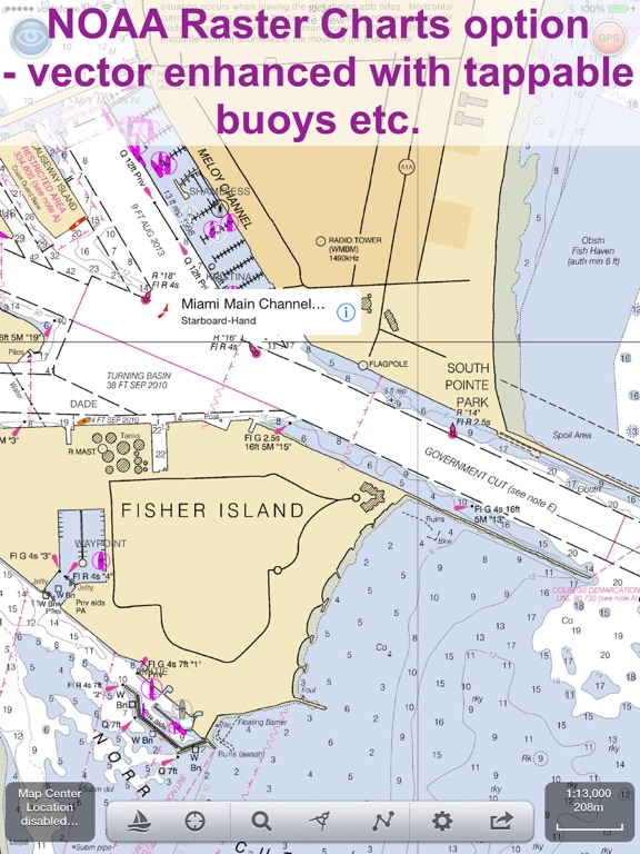
Built from official hydrographic data with extensive coverage across North America, Europe and Australia.
Professional marine navigation features including:
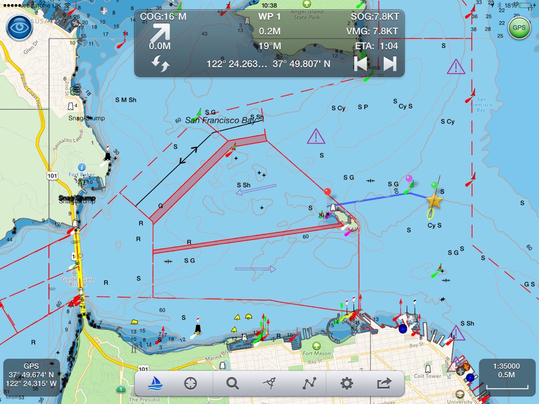
Planning
• Create and edit routes with auto-routing for creating waypoints
• Measure distance & bearing
• Import & export GPX routes
• Tides, Streams & Weather
• Works offline
Navigate with Confidence
• Real-time GPS navigation
• Course Up & North Up modes
• ETA, XTE, VMG, SOG & COG
• Sailing HUD display
• Background navigation
• Automatic Waypoint advancing & alerts
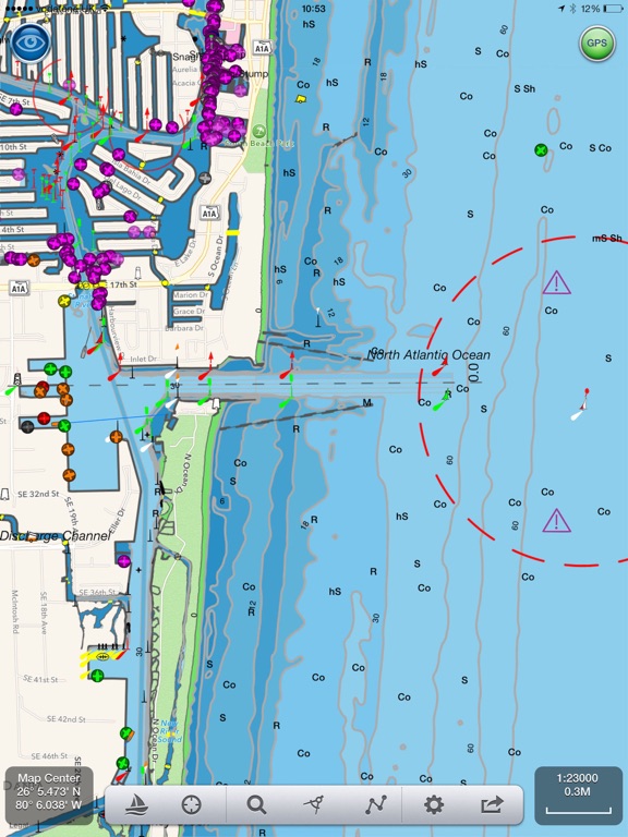
Live AIS & Safety (Optional IAP)
• Real-time AIS ship positions
• Collision alarms
• AIS position sharing
• Internet AIS integration
• Free AIS when used with Boat Beacon
• MOB and Anchor alarm (IAP)
- NMEA Link for Depth, Wind & AutoPilot
- Real time local wind feed and Sailing laylines display (IAP)
Alongside this SeaNav offers advanced onboard capabilities rarely found in a single app:
Apple Watch app
SeaNav for Apple Watch is included at no extra cost, giving you route data, key navigation information and quick access controls directly from your wrist.
Sophisticated AIS Display and Position sharing
The leader in the field with global coverage and clear, information-rich vessel tracking with intelligent filtering and collision prediction tools.
CPA and TCPA alerts help you assess risk early and act confidently.
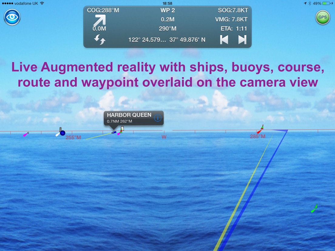
Augmented Reality View
Overlays navigation, AIS and chart data directly onto the real-world camera view for intuitive situational awareness.
Includes night mode support for compatible thermal cameras such as FLIR.
SeaNav Autoroute and Autopilot Integration
- Just choose where you want to go and SeaNav will create the route for you
- Go one step further and let SeaNav pilot the route with compatible autopilot systems from Raymarine, SIMRAD, Lowrance and B&G
SeaNav comes with a built-in tutorial mode with free access to all features including charts, AIS, AR & wind
The free version includes all navigation and trip planning tools. High resolution vector charts are available by In App Purchase (IAP) including updates for 12 months.
Requirements:
GPS only required for real time route navigation. Optional Real time AIS, Tides and Weather information require an active internet connection.
WiFi-only iPad will need an external GPS receiver for navigation.
Please note that continued use of GPS running in the background can dramatically decrease battery life.
Subscriptions
Our in-app purchases are 1 year subscriptions, which automatically renew at the end of the subscription period unless auto-renew is turned off at least 24-hours before the end of the current period. Payment will be charged to your iTunes Account at confirmation of purchase, and will be charged for renewal within 24-hours prior to the end of the current period.
Subscriptions may be managed by the iTunes account holder and auto-renewal may be turned off by going to Account Settings after purchase. No cancellation of the current subscription is allowed during active subscription period.
NOTICES: This product has been derived in part from material obtained from the UK Hydrographic Office with the permission of the UK Hydrographic Office, Her Majesty’s Stationery Office.” “© British Crown Copyright, [2026]. All rights reserved.
The UK Hydrographic Office (UKHO) and its licensors make no warranties or representations, express or implied, with respect to this product. The UKHO and its licensors have not verified the information within this product or quality assured it.
Terms of Use: http://seanav.net/termsofuse.php
Privacy Policy: http://seanav.net/privacy.php
Support: help@pocketmariner.com
--
SeaNav van Pocket Mariner Ltd. is een app voor iPhone, iPad en iPod touch met iOS versie 15.6 of hoger, geschikt bevonden voor gebruikers met leeftijden vanaf 4 jaar.
Informatie voor SeaNavis het laatst vergeleken op 23 Jun om 16:57.


Informatie
- Releasedatum:24 Apr 2014
- Bijgewerkt:18 May 2026
- Versie:5.5.5
- Compatibiliteit:Vereist iOS 15.6 of nieuwer. Compatibel met iPhone, iPad en iPod touch.
- Grootte:166 MB
- Leeftijd:4+ jaar
- Beoordeling:4.4 van 5
- Categorie:
Nieuw in versie 5.5.5
Improvements to Auto-routing
Meer van Pocket Mariner Ltd.

Reageer op deze app
Dit vind je misschien ook leuk
Laatste reacties
- Hank zei over Klaverjas HD: "Waardeloze update, geld wordt uit de zak geklopt. Advies: niet..."
- Sterre zei over AU3FX:Space: "Leuk artikel over deze app! Voor mensen die hun gitaar willen..."
- Kaneeltje zei over WordOn HD: "Hou op met steeds te vragen hoe ik dit spel vind. Heb nu de..."
- Ciao zei over Solitaire Grand Harvest: "Ciao"
- René zei over PostNL: "Het eerste scherm van de app laad niet Ik heb ios 16 wat kan..."
- Fam van Beek zei over Woodoku - Houten Legpuzzels: "Afgelopen maanden steeds meer reclames die je helemaal moet..."
- Stephen zei over Justin Guitar: Gitaar Stemmer: "Voor iedereen die ook zonder app zijn gitaar snel wil stemmen,..."
- Wim van Gastel zei over My BMW: "Sluit me aan bij eerdere reacties. Het percentage van de..."
- Paul Bergervoet zei over MYPEUGEOT APP: "In en intrieste app. Ook de ondersteuning via de..."