LET OP: Aankopen verlopen via de App Store, bekijk daar altijd de meest actuele prijs, compatibiliteit en andere informatie. Je hebt een actief Apple account nodig om apps te installeren.
“MapOut saves the day with its intuitive interface for drawing routes and viewing elevation profiles. I’m genuinely impressed by its powerful features!” – Alee, cyclingabout.com
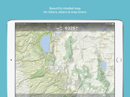
Offline maps covering the entire globe, optimized for iPhone and iPad. As beautiful as a traditional paper map—but far more versatile.
Perfectly tailored for:
- Hikers: Clear, detailed terrain maps accessible even in the most remote locations, without an internet connection.
- Cyclists: Extensive cycling route network with real-time speed and distance tracking.
- City Travelers: Detailed city maps complete with essential tourist information.
- Map Enthusiasts: Simply elegant maps that are a pleasure to view.
Innovative 3D Tilt View
- Tilt your device in any direction to vividly explore terrain details. Learn more at [mapout.app](https://mapout.app).
Powerful Offline Search
- Easily find places, streets, mountains, and more—no internet needed.
High-Quality Map Data
- Built upon the OpenStreetMap project, the "Wikipedia of Maps". Contribute your own corrections and additions at OpenStreetMap.org.
- Regularly updated offline maps available for your selected regions.
Effortless Tour Planning
- Draw: Easily create custom routes and waypoints directly on your map. Adjust existing tours or imported GPX files effortlessly.
- Import: Transfer routes to your device via email using a free "MapOut.me" account. Discover countless GPX and KML route files online, ideal for hiking or biking (e.g., gpsies.com).
- Record: Capture your adventures and easily share them with friends.
- Insights: Quickly see vital information for every tour—distance, elevation changes, route profile, and map details.
Superior Map Viewing Experience
- Rapid, hardware-accelerated rendering for smooth navigation.
- Continuous zoom with impeccable clarity at every level.
- Detailed topographical views featuring contour lines and shading.
- Versatile overlays include biking, hiking, skiing routes, sightseeing locations, and public transport networks.
Find comprehensive support and answers in our user manual: https://mapout.app/manual
Map data © OpenStreetMap contributors https://www.openstreetmap.org/copyright
--
MapOut van Valnova is een app voor iPhone, iPad en iPod touch met iOS versie 11 of hoger, geschikt bevonden voor gebruikers met leeftijden vanaf 4 jaar.
Informatie voor MapOutis het laatst vergeleken op 5 Feb om 12:53.
Informatie
- Releasedatum:20 Mar 2012
- Bijgewerkt:27 May 2025
- Versie:3.4.13
- Compatibiliteit:Vereist iOS 11 of nieuwer. Compatibel met iPhone, iPad en iPod touch.
- Grootte:74.8 MB
- Leeftijd:4+ jaar
- Beoordeling:4.9 van 5
- Categorie:
Nieuw in versie 3.4.13
- fixed bug in dashboard
Prijsgeschiedenis
46 geschreven reviewsRecensies
Just great
MeerThis is so much better than any other app I have used during cycling holidays. None of the bureaucracy of navigating Komoot menus for starting or updating tours. It’s just simple and quick. Can do all planning and route updating offline. Very user intuitive. Great maps. Good visibility during the ride. Low battery usage.
5door Anoniem20/06/2025Accuraat
MeerFijne zeer handzame app. Werkt snel en is zeer nauwkeurig en daarom erg goed bruikbaar voor navigatie bij slecht zicht.
5door Mar*******12/11/2024Almost perfect
MeerI just wish the track currently being recorded were a different colour to previous recordings.
And it would be cool to be able to click on POIs and look them up on Google Maps, Wikipedia, etc.
Edit: just wishing for a dark mode icon for iOS 18!4door Pat*******16/09/2024
Reageer op deze app
Dit vind je misschien ook leuk
Laatste reacties
- Pieter Nieuwenhuis zei over Klaverjas HD: "Wij spelen regelmatig met 4 vrienden, verdeeld over Europa...."
- Bep vreeswijk zei over Oei, ik groei!: "Jammer,ik speelde het jaren lang voor koopprijs,eenmalig,was..."
- Bep vreeswijk zei over Oei, ik groei!: "Ik kocht het spel,was duur in vergelijking tot anderen en zou..."
- EBB zei over QuizzLand Algemene Kennis Quiz: "Terwijl ik midden in het spel zat en klikte was er plotseling..."
- Mary zei over Klaverjas: "Kan je met vrienden spelen of alleen maar met de computer?"
- Allard Postmus zei over WordOn HD: "Ik heb een probleem met Wordon wat betreft de totaal stand Ik..."
- Leo zei over Vita Mahjong: "Na de update is het spel veranderd en niet ten goede. Ook had..."
- Dion zei over Bonnetje: "Teleurstellende ervaring, onduidelijke communicatie en..."
- Bert Maas zei over PaperCal: "Gebruik papercal al jaren tot volle tevredenheid, maar opeens..."


Reacties
Voor mij de perfecte app om routes te maken, wandelen, ATB, gravel of verhard.
Eenvoudig in gebruik en sneller dan welke andere tool ook.
A great app for making routes, on and off-road.
The fastest tool and super simple, a miracle.