
LET OP: Aankopen verlopen via de App Store, controleer daar altijd de meest actuele prijs, compatibiliteit en andere informatie. Je hebt een actief Apple account nodig om apps te installeren.
Unleash the navigation potential of your iPhone or iPad with iHikeGPS NZ! Turn your device into a high-performance GPS receiver with the official LINZ New Zealand topo maps. These maps have many valuable back country details to keep you informed and safe.
Even in remote areas with no cell signal, iHikeGPS NZ ensures you always know where you've been, where you are, and where you’re going. Experience the ultimate hiking companion, offering unparalleled track recording, route navigation, and accurate Estimated Time of Arrival.
One Low Price! Everything included. No sign-ups, ads, subscriptions or in-app purchases. Completely respects your privacy.
Discover the limitless possibilities of iHikeGPS for walking, hiking, trekking, tramping, running, biking, backpacking, canoeing, kayaking, geocaching, camping, sightseeing, 4 wheeling, skiing & hunting, .
TRACKS, WAYPOINTS & ROUTES
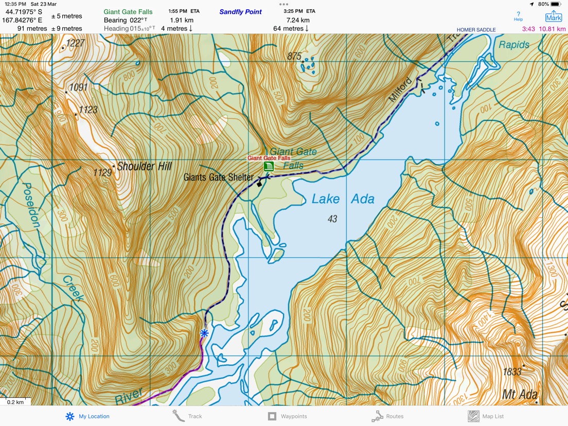
Record Tracks as you walk, even in the background. View them on the map with a Trip Timer and Odometer.
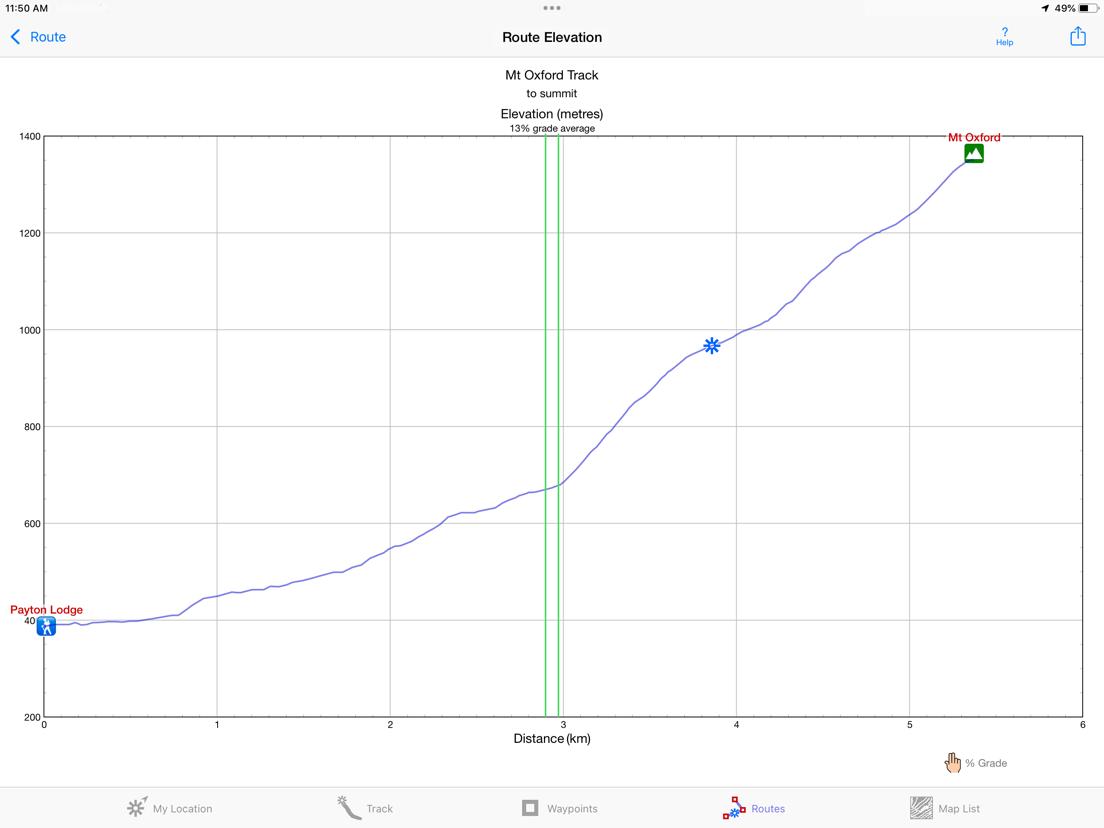
View elevation graphs of your Tracks and Routes. Show date, time, average speed, % grade & the area inside a closed path.
Mark Waypoints precisely using topo or satellite maps, place names or addresses, geotagged photos or by projecting from a known point.
Get the elevation above sea level for any location from a Digital Elevation Model database.
Set a quick GoTo Waypoint or a full Route & see the heading, direction, distance, elevation change and Estimated Time of Arrival at your destination and at intermediate waypoints along the trail. Be warned when you leave a Route you were following.
Create customized routes using Waypoints, recorded Tracks, or imported GPX, KML or TCX files.
Advanced Route editing.
Send GPX and KML Waypoint, Route, Track and Map List files via AirDrop, eMail, Messages, or iCloud Drive.
View the sun & moon positions and rise & set times for any date & place.
Send data to other apps such as Google Earth.
TOPO MAPS AT NO EXTRA COST
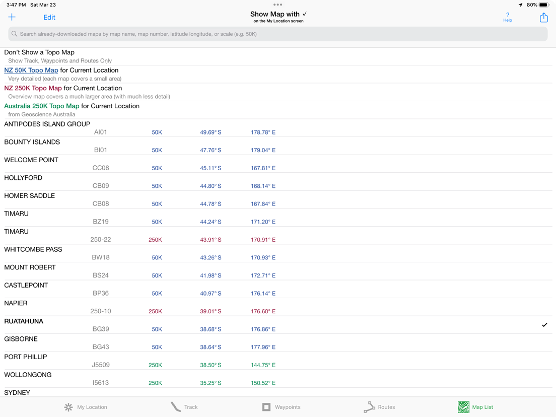
The latest up to date version of official Land Information New Zealand (LINZ) 50K & 250K scale topo maps, including NZ off-shore islands.
Free Bonus: Official Geoscience Australia 250K scale maps. (No smaller scale maps for Australia).
Download using WiFi or cell service. Our maps are optimized to download faster and use less storage memory. Store a few maps or all maps for both countries to use in the wilderness without cell service.
These beautiful richly detailed high resolution offline topographic map images stitch together for seamless coverage across map boundaries.
Includes map legends.
Print and Share map images overlaid with Waypoints, Routes and Tracks.
Measure distance and direction between any 2 points.
USE THE UNITS YOU PREFER
Kilometers, Miles, or Nautical Miles.
Meters or Feet.
Degrees, Degrees/Minutes, Degrees/Minutes/Seconds, UTM, or NZTM2000 grid.
°True or °Magnetic.
HOW TOS
Comprehensive Help in the App
Online Manual on iHikeGPS.com/nz
Email developer: lwjames@iHikeGPS.com
WHAT OTHERS SAY
“This app saved my life! *****
This app was downloaded, while lost in the Kaimai Ranges. GPS quickly located position, app quickly (ish) downloaded the relevant NZ topo map. From there easily identified position on the map. Outcome, life saved. And my mates who by this stage was getting all girly about it all. Best app ever!!!” - Jk9624 on the UK App Store
“I have used your ihike app for many years tramping in NZ. It is fantastic and absolutely the best off line navigation app out there.” - Paul, an internationally-known documentary film maker in Wanaka, New Zealand
DEVICE REQUIREMENTS
Use iHikeGPS NZ on any iOS device even if you don't have a cellular data plan for it. iPhones and WiFi+cellular iPads support full navigation. WiFi-only iPads and iPod touches can view maps, but require an iOS-compatible external GPS receiver to show your location and record tracks.
Join thousands of satisfied users who rely on iHikeGPS NZ for their outdoor adventures!
--
iHikeGPS NZ : LINZ Topo Maps van James Associates Inc. is een app voor iPhone, iPad en iPod touch met iOS versie 12.0 of hoger, geschikt bevonden voor gebruikers met leeftijden vanaf 4 jaar.
Informatie voor iHikeGPS NZ : LINZ Topo Mapsis het laatst vergeleken op 3 Jul om 02:48.


Informatie
- Releasedatum:22 Dec 2011
- Bijgewerkt:24 Apr 2026
- Versie:9.6.9
- Compatibiliteit:Vereist iOS 12.0 of nieuwer. Compatibel met iPhone, iPad en iPod touch.
- Grootte:11.1 MB
- Leeftijd:4+ jaar
- Categorie:
Nieuw in versie 9.6.9
Improved wording on some Alerts and Notifications.
What's new in iHikeGPS NZ compared with other available New Zealand topo map apps?
• Real Navigation Power: Unlike other apps that simply display waypoints and routes on a map, iHikeGPS NZ empowers you to do real navigation to those waypoints and along those routes while receiving crucial information such as Estimated Time of Arrival, current bearing, and remaining distance and elevation gain to intermediate and final destinations. Use iHikeGPS NZ when you are on the trail and away from cell service. For your safety on the trail it always works no matter where you are hiking without requiring an Internet connection.
• You can view elevation graphs of your Tracks and Routes with Waypoints, speed and % grade shown on them.
• You can view elevation graphs of your Tracks and Routes with Waypoints, speed and % grade shown on them.
• You can create, import, edit, and navigate both on routes based on a recorded or imported path, and on routes based on a series of waypoints.
• There is never any confusion over what maps you have available offline. They are clearly listed and shown on an overview map.
• iHikeGPS NZ' s code size is kept very small by efficient programming so in an emergency, you can download it easily even over a weak cell connection.
• The current version of iHikeGPS NZ runs on the latest devices and also on older devices with older versions of iOS , all the way back to devices such as the iPhone 6.
• Check the App Privacy section. We don't know who you are when you are using iHikeGPS NZ. We never send your current location or your recorded track to our servers. Hence we cannot and don't use your location data. We cannot and don't provide your location data to anyone else. Unlike other mapping apps that profit from using your location data in ways that do not keep it private, iHikeGPS NZ maintains the highest level of data confidentially.
Posted on YouTube: "On that day I was using iHikeGPS app to track… When I'm doing any exploration hike, this is the app I would always use to make sure I will be able to return to my car. I've encounter dead zone areas where there's no internet signal, some apps will freeze and stop working… I would not rely on using those … apps for exploration hikes. As basic iHikeGPS appears to be, it continues to work flawless without internet. To this day I continue to use iHikeGPS for certainty and survival." - Carlos
Prijsgeschiedenis
Reageer op deze app
Dit vind je misschien ook leuk

Laatste reacties
- sara zei over FarmVille 2: Het boerenleven: "Maanden ben ik al in contact met Zynga over valsspelers bij de..."
- Aahil khan Aahil khan zei over Subway Surfers Tag: "Uhhcgdogv"
- Aahil khan Aahil khan zei over Subway Surfers Tag: "Ygxgxbzbuuurjhbxvxv"
- Danish zei over NPO Start: "Hello, I was analyzing www.appwereld.nl and noticed several..."
- Hank zei over Klaverjas HD: "Waardeloze update, geld wordt uit de zak geklopt. Advies: niet..."
- Sterre zei over AU3FX:Space: "Leuk artikel over deze app! Voor mensen die hun gitaar willen..."
- Kaneeltje zei over WordOn HD: "Hou op met steeds te vragen hoe ik dit spel vind. Heb nu de..."
- Ciao zei over Solitaire Grand Harvest: "Ciao"
- René zei over PostNL: "Het eerste scherm van de app laad niet Ik heb ios 16 wat kan..."