
LET OP: Downloads verlopen via de App Store, bekijk daar altijd de meest actuele prijs, compatibiliteit en andere informatie. Je hebt een actief Apple account nodig om apps te installeren.
*30 Days Free Trial on initial download!*
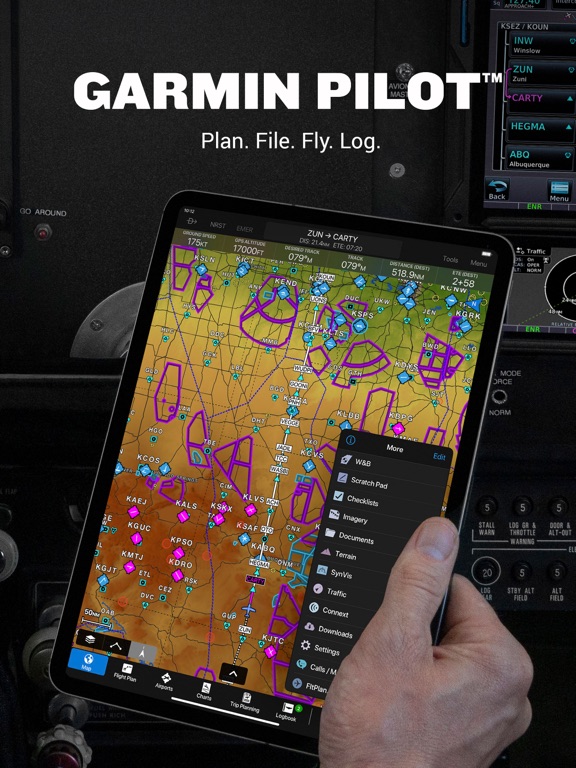
Plan. File. Fly. Log.
Garmin Pilot is the most comprehensive suite of tools for the iPad designed specifically for general aviation and corporate pilots. Flight planning, charts, interactive maps, weather briefing resources and navigation capabilities; it’s all included. The app’s intuitive interface mirrors those on the newest Garmin touchscreen avionics so you can go seamlessly from preflight to inflight.
Plan
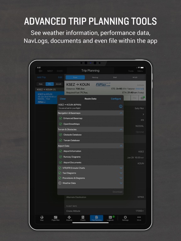
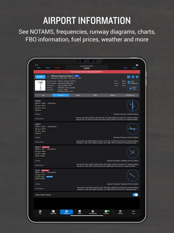
Garmin Pilot’s powerful capabilities start with pre-flight planning, providing pilots with the most comprehensive aviation weather information to make better-informed flight decisions. Pilots can check NEXRAD radar, visible and infrared cloud imagery, METARs, TAFs, AIRMETs, SIGMETs, PIREPs, NOTAMs, winds and temperature aloft, TFRs and lightning data. With Garmin Pilot, data can be displayed over Garmin’s interactive maps that support track-up navigation, VFR sectional or an IFR low or high en-route chart to visualize the weather for your route. Add text-based weather widgets and use the exclusive NavTrack feature to view weather along the planned route.
File
With Garmin Pilot, users can easily enter a flight plan and interactively edit it on the map. Pre-loaded forms make it quick to save and reuse data for frequently flown routes. And when the flight plan is ready, Garmin Pilot makes it simple to file, amend or close the flight plan via Leidos Flight Service or DUATS.
Fly
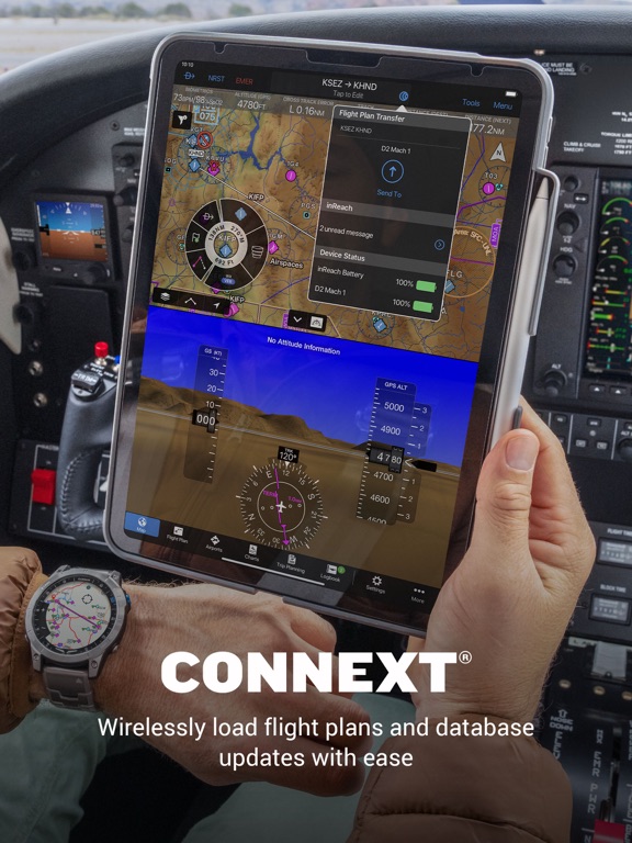
Garmin Pilot provides full en-route navigation capability on its moving map. Pilots can also navigate with Garmin’s patented panel, a GPS-driven instrument pack with a graphical HSI directional display and indicators for groundspeed, altitude and vertical speed. After takeoff, pilots can continue to view real-time weather in the U.S. and traffic information by wirelessly connecting to Garmin’s GDL 50 series portable ADS-B Receiver (sold separately).
Log
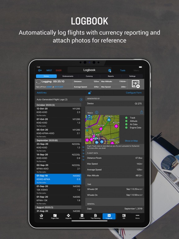
Garmin Pilot includes a comprehensive electronic logbook that syncs with flyGarmin. The logbook automatically generates entries based upon GPS data collected during the flight, tracks currency, supports manual entries, endorsements and creates reports.
Garmin Pilot U.S. Standard:
- Rich, interactive maps support Track-Up navigation
- Charts: VFR Sectionals, low and high IFR en-route, airport diagrams and approach procedures
- Ability to view Jeppesen Terminal Charts (Jeppesen echart subscription required)
- Weather Maps: Animated radar, Infrared and Visible Satellite, AIRMETs, SIGMETs, Lightning, TFRs and more!
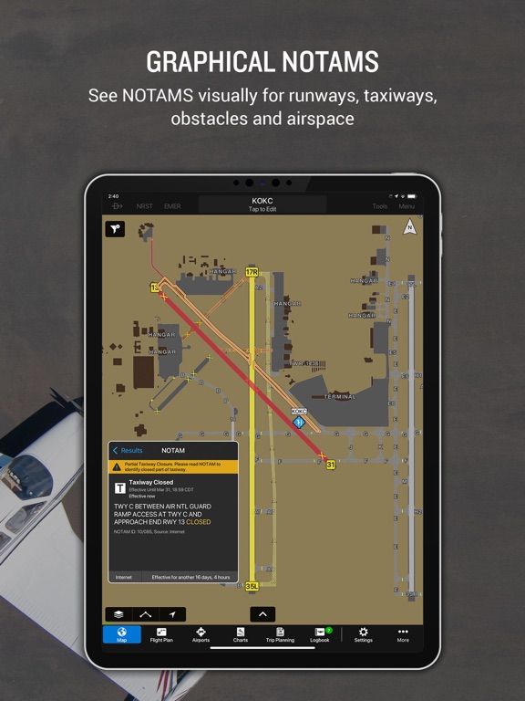
- Extensive text products: METARs, TAFs, Winds Aloft, PIREPs, AIRMETs, SIGMETs, Area Forecasts and NOTAMs
- AOPA Airport Directory
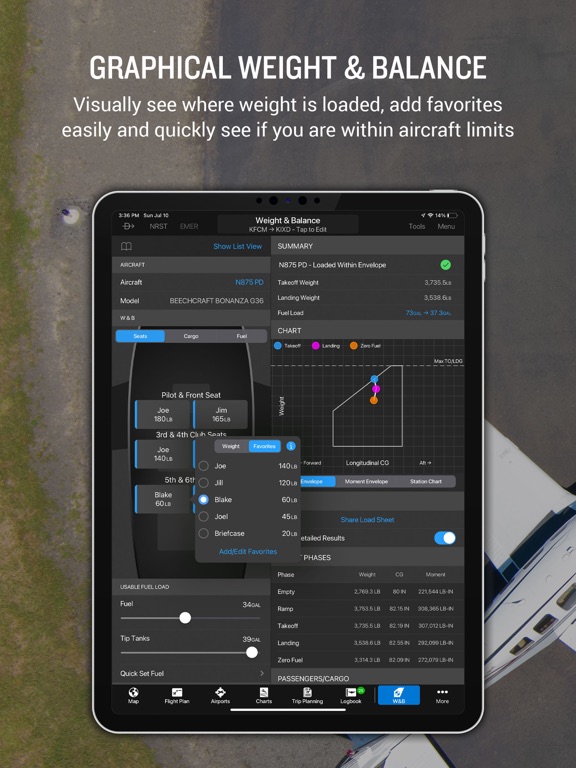
- Weight and Balance
- Checklists
- Flight plan filing via Leidos Flight Services
- Garmin patented navigation panel
- Terrain and Obstacles
- Smart Airspace
- Fast Find predictive Waypoint Entry
- Logbook
- Optional VFR Premium: Synthetic Vision (SVX), Terrain and obstacle alerting, and Garmin SafeTaxi®
- Optional IFR Premium: VFR Premium plus geo-referenced Garmin FliteCharts®
Garmin Pilot has regional offerings for Africa, Asia, Australia, Canada, Europe and Latin America. Features include:
- Worldwide Jeppesen NavData
- Rich, interactive maps support Track-Up navigation
- Radar and Satellite imagery for Western Europe, U.S., Canada and Australia
- Ability to view Jeppesen Terminal Charts (Jeppesen echart subscription required)
- Worldwide METARs, TAFs, AIRMETs, SIGMETs, NOTAMs and winds aloft
- VFR Flight Plan Filing
- IFR autorouting and Flight plan filing in Europe
- Terrain and Obstacles with alerting
- Synthetic Vision (SVX)
- Smart Airspace
- Logbook
- Optional VFR charts from DFS, IGN and NATS and IFR enroute charts from EuroControl
- Optional Garmin FliteCharts® and SafeTaxi® diagrams available on a country-by-country basis
*Note: Use of GPS running in the background may decrease battery life.*
*Note: One subscription to Garmin Pilot may be used on three devices.*
--
Garmin Pilot van Garmin DCI is een app voor iPhone, iPad en iPod touch met iOS versie 18.0 of hoger, geschikt bevonden voor gebruikers met leeftijden vanaf 4 jaar.
Informatie voor Garmin Pilotis het laatst vergeleken op 2 Jul om 23:30.

Informatie
- Releasedatum:17 Jul 2014
- Bijgewerkt:15 Jun 2026
- Versie:26.6.0
- Compatibiliteit:Vereist iOS 18.0 of nieuwer. Compatibel met iPhone, iPad en iPod touch.
- Grootte:572 MB
- Leeftijd:4+ jaar
- Beoordeling:4.8 van 5
- Categorie:
Nieuw in versie 26.6.0
- New! Daily Weather Forecast
- New! Turbulence Map Layer for U.S. subscribers
- Expanded radar coverage to include the Dominican Republic
- Restored ability to display user waypoints on satellite image
Meer van Garmin DCI

Reageer op deze app
Dit vind je misschien ook leuk
Laatste reacties
- sara zei over FarmVille 2: Het boerenleven: "Maanden ben ik al in contact met Zynga over valsspelers bij de..."
- Aahil khan Aahil khan zei over Subway Surfers Tag: "Uhhcgdogv"
- Aahil khan Aahil khan zei over Subway Surfers Tag: "Ygxgxbzbuuurjhbxvxv"
- Danish zei over NPO Start: "Hello, I was analyzing www.appwereld.nl and noticed several..."
- Hank zei over Klaverjas HD: "Waardeloze update, geld wordt uit de zak geklopt. Advies: niet..."
- Sterre zei over AU3FX:Space: "Leuk artikel over deze app! Voor mensen die hun gitaar willen..."
- Kaneeltje zei over WordOn HD: "Hou op met steeds te vragen hoe ik dit spel vind. Heb nu de..."
- Ciao zei over Solitaire Grand Harvest: "Ciao"
- René zei over PostNL: "Het eerste scherm van de app laad niet Ik heb ios 16 wat kan..."